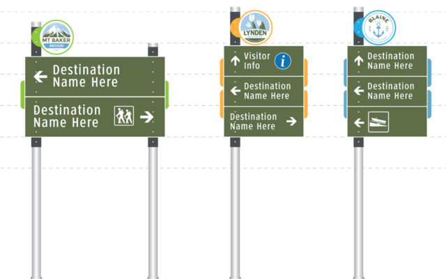
Communities

Sandy Springs

The City of Sandy Springs is metropolitan Atlanta’s second (2nd) largest city. With a geographic area of 38 square miles, the city includes, several hundred acres of parkland, 22 miles of shoreline along the Chattahoochee River, including three units of the National Park Service. There are also three MARTA rail stations that serve the community, providing park-n-ride service to Atlanta and access to the Sandy Springs Medical District and Perimeter Business District.

The City has hired MERJE to plan and design a comprehensive wayfinding program. Primarily a vehicular oriented system and with expected circulation changes in the next 5 years due to new highway access points, the system is modular and easily updatable. The design is heavily branded with the Sandy Spring identity, but also changes in aesthetics as a visitor transitions from the modern suburban areas of town to the rural wooded neighborhoods and parks. Pedestrian signs and kiosk will be included in City Spring District and the Perimeter Business District, helping to promote events, make connections to public transit and orient users to the city and region in general. MERJE is also coordinating with GDOT and the National Park Service to gain project approvals.

Mansfield, TX

The City of Mansfield is one of the 60+ municipalities that together constitute the Dallas/Fort Worth Metroplex. Mansfield is approximately 38 square miles in size, the third largest city in Tarrant County and has a population of 68,000 that is projected to grow to 130,000.

The story of the wayfinding design is the tale of 2 individual but common systems. The core of the program, Historic Downtown Mansfield, establishes the design framework. The sign configuration, shape and size reflect the local architecture. Historic colors, local materials and details connect it to the surrounding environment.

Once beyond the downtown boundaries the system colors and logo change to the full Mansfield identity and become more modern for the surrounding suburban neighborhoods and higher speed roadways. Additional adjustments to design were also made for the specific TXDOT requirements for signs that fall in the State right-of-way. A Steering Committee, as well as City Council was highly involved in all aspects of the design process.

Brandywine Valley

The Brandywine Valley spans parts Chester County, Pennsylvania and New Castle County, Delaware. It is famous for the national treasure of Longwood Gardens, but it also holds countless museums, historic sites, wineries, theaters, parks, and arboretums. Plus, there are several vibrant and charming downtowns and historic districts with dining for every palette, and shopping for every taste. Connecting the region is the Brandywine River, winding through forests and along scenic byways, offering recreation and inspiration to visitors and residents alike.

MERJE was hired to develop a regional wayfinding system that will easily direct visitors to these attractions. Working with two DOTs, two Visitor Bureaus, several municipalities and stakeholders, a design was developed to work across the entire region, in rural areas and towns alike. The rolling hills and gentle current of the Brandywine river is the inspiration for the cut graphic panel at the top of the signs. The color palette is drawn from the identities of the two Visitors Bureaus and the boutique wine industry growing in the region.

Rehoboth Beach

Rehoboth Beach is a one square mile community located on the Delaware coast. Known as the “Nation’s Summer Capital”. The town was historically branded as the get-a-way of choice for beach goers from Washington, D.C. Now, this beach town hosts visitors from all over the country, and the world and is now known as a year round vacation destination for business and pleasure.

MERJE worked with the city on the design and planning of a comprehensive wayfinding program that focuses first on parking, as well as gateways, pedestrian signage and kiosks. The design reflects the Rehoboth Beach brand and incorporates specific materials and finishes to protect the signs from the harsh coastal environmental conditions.

The system is also being developed along with southern Delaware tourism and the City of Lewes, to create a coordinated regional wayfinding system.

Asheville River Arts District

The River Arts District in Asheville, North Carolina is an area of former industrial buildings located near the French Broad River. Visitors can experience working studios and galleries of hundreds of artists, showcasing painting, pottery, jewelry, glass, metal, wood and much more.

MERJE has been working with the Asheville Convention and Visitors Bureau for over 10 years on a variety of wayfinding programs. The CVB, along with the River Arts District (RAD), approached MERJE to help extend the Citywide program to a more detailed RAD wayfinding program.

Working with the existing RAD identity, MERJE designed wayfinding signs, kiosks and landmarks to help promote the district and make it easier for visitors to locate the various artist studios. The design utilizes components of the citywide wayfinding program, also designed by MERJE, but incorporates unique elements that capture the eclectic and authentic environment of the creative district.

Cabarrus County

Cabarrus County “Where Racing Lives” is home to an unequaled concentration of motorsports attractions including Charlotte Motor Speedway, zMAX Dragway, and top NASCAR team headquarters. Visitors can also experience museums, art galleries, live theaters, a botanical garden, eclectic shopping, fine dining and more all within a radius of two city blocks in Historic Downtown Concord.

The Cabarrus County Convention and Visitors Bureau, contracted with MERJE to design and plan a County-wide wayfinding program that connects 5 municipalities and the various community assets and attractions. The design is modern and sleek, reflecting the Cabarrus County brand. Working with the County, Cities, and NCDOT, the program includes vehicular signage around the County and pedestrian scale elements in the individual downtowns. Each municipality retains their own personal identity through the use of their own color and logo graphics. The program is scheduled for installation for late summer of 2017.

Miami Downtown

The vision of the Miami Downtown Development Authority (DDA) is to create a “new Downtown Experience” that will showcase all the quality of life advantages of urban living in an exciting Downtown Miami setting and community that has the diversity, sense of place, economic vitality, and “round the clock” activity that makes great cities.
The DDA contracted with the design team of MERJE and Gannett Fleming to develop a signage and wayfinding system for Downtown Miami. The program is designed to project a consistent image for the downtown area; ease vehicular congestion; guide visitors to landmarks, facilities, and services; promote walking, bicycling and mass transit; and be sustainable as well as expandable.

Gateway elements mark the arrival to downtown and a color-coded icons mark the three primary districts. The sign materials and form are clean, simple and modern, fitting into the context of the downtown environment and style of Miami.

Yadkin Valley Orientation Map Kiosk

Yadkin Valley

The Yadkin Valley Heritage Corridor Partnership is a tourism and economic development collaboration among four counties in northwestern North Carolina, a region rich in vineyards, history, culture and recreational assets. The Partnership engaged MERJE to lead a team of multi-disciplined firms in designing an extensive wayfinding and branding program for the Valley, which spans a 129-mile corridor.

A new regional identity and website, as well as smart phone applications and printed brochures, are part of the wayfinding program developed for the Partnership. Other components of the program include new gateway and vehicular signage at multiple locations, information kiosks, municipal banners and an interactive trails exhibit.

Whistler British Columbia Wayfinding

Whistler, B.C.

Passion and resourcefulness characterize the residents of this mountain resort community. Drawn into the spotlight when Whistler hosted the 2010 Winter Olympics, the picturesque village with abundant trails, parks and woods has been strategically developed and maintained for a growing tourist and residential population.

To make the most of natural and man-made resources, Whistler engaged MERJE and Brent Harley Associates to develop a Wayfinding Master Plan and Arrival Experience strategy that begins at the Vancouver Airport. The strategy includes a set of recommendations designed to guide visitors to the resort and easily access the amenities during their stay. Both digital wayfinding and physical signage will be used to effectively support the needs of first-time and frequent visitors. The municipality’s aim is to improve functionality of wayfinding infrastructure and contribute to the overall enjoyment of the resort.

Tri-Cities

Tri-Cities, a growing metropolitan area in southeast Washington where 300 sun filled days offer visitors a year round outdoor paradise. Fun in the sun is a way of life in the Tri-Cities–one reason it’s among of the most popular spots for Washington vacations. The Visit Tri-Cities Convention and Visitors Bureau began to roll-out their new brand identity and slogan “ Brighter Bolder Better”, with a new website and marketing materials, the natural next step was the development of a new wayfinding program that would help connect the 4 major cities of Pasco, Kennewick, Richland and West Richland.

In addition to the comprehensive wayfinding program, MERJE is assisting with developing the strategies for the administrative aspects of this regional wayfinding program, including management, maintenance and funding opportunities. The project includes gateways, orientation maps, vehicular and pedestrian elements that reflect the new brightly colored logo and the Tri-Cities outdoor experience.