parks + trails

Whistler Parks

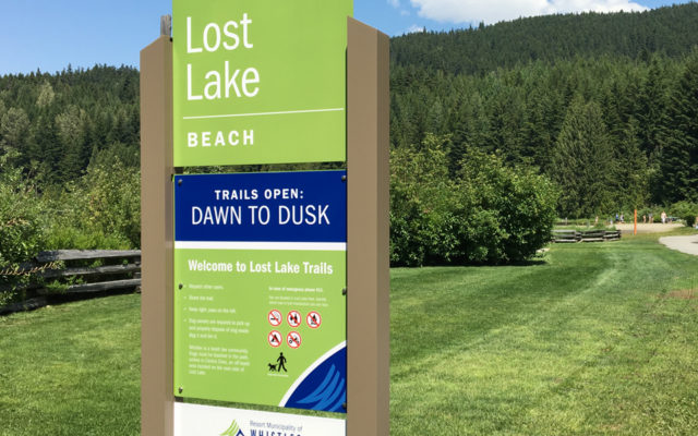
Opportunity for outdoor recreation is everywhere in and around the Resort Municipality of Whistler (RMOW), in British Columbia. In addition to the epic ski slopes, there are robust parks and trails systems. There are over 40 parks ranging from small neighborhood green spaces, to large parks with numerous facilities. The gem of the trail system is The Valley Trail: a paved path that connects the entire region that serves as the connection between many of the parks.

MERJE designed a new comprehensive design guideline for Whistler Parks and signage for the Valley Trail. The systems work with the RMOW identity and utilize design elements used in the Whistler Village Wayfinding Program that was also designed by MERJE. Natural basalt stone accents and angular shapes create a design that is unique and of its place.

Whistler Cultural Connector

Whistler Cultural Connector

The Whistler Cultural Connector (WCC) project is a unique and separate layer of the wayfinding experience in Whistler. The project relies more on discovery than literal directional information. The project looks to celebrate Whistler’s emergence as a vibrant cultural destination and improve the physical, visual, experimental and branded connectivity between six cultural institutions in Whistler.

The institutions include, Whistler Museum and Archives, Whistler Public Library, Millennium Place, the Audain Art Gallery, the Squamish Lil’wat Cultural Centre and Passiv House at the trail head to Lost Lake. MERJE has created a branded wayfinding system that acts more as an experience you come across and discover through repetition. The design utilizes a black, white and yellow pattern that is applied to different elements and at different scales and configurations.

Valley Path

Valley Path

Metropolitan Phoenix has more than 3,000 miles of trails that the region is working hard to develop into a massive, off-street bicycle network. MERJE and Alta Planning and Design developed an identity and wayfinding guide that connects the trails graphically, improves access and safety for users, and boosts the city’s efforts to engage public support for the trail network.

United trails NE Indiana

United Trails

Miles of paved paths existing within Northeastern Indiana have the goal of one day becoming a connected regional network for families, health advocates, and commuters to utilize and take them to various regional destinations. Still evolving, this Regional Trail System required an identity that captured all of its assets, character, uses and potential.

The Trail System is used in many ways by many people, but at its core, connectivity to different areas of the Northeastern Indiana Region is what makes the trail special and a huge asset to the Region. MERJE developed an identity for this regional trail system, which will expand to include wayfinding signage and marketing materials. Through a series of branding exercises which involved the steering committee, stakeholders and the general public, MERJE built consensus for the trail name, tagline and logo. The local trails will have the option to be included in the regional trail system, either with a new trail logo or by utilizing the wayfinding signage on their already-established trails.

Tampa Riverwalk

Tampa Riverwalk

Tampa Riverwalk is a 2.4-mile recreational pathway along the river in downtown Tampa for which MERJE designed interpretive signage that highlights natural and man-made points of interest, wayfinding that indicate transportation nodes and cultural sites, and map kiosks with solar panel canopies that illuminate the maps in the evening.

Focal elements communicate historical and educational interpretive information, as well as directional signage and maps as a wayfinding component. Complimenting these large scale, multifunctional focal elements, smaller components contain similar types of information such as distance markers for those who come for exercise.

Newark Walks

Newark Walks is a mobile app that guides users on a tour of the City’s cultural landmarks and historic sites, providing fun facts about each destination. Designed by MERJE and Winfield & Co., the app also provides a calendar of cultural events and can be customized to monitor calories burned and distance traveled. MERJE also designed a printed brochure and map, as well as interpretive panels at the destinations.

Friends of Wissahickon

Wissahickon Valley Park

The Friends of the Wissahickon (FOW) is a 1,600 member, non-profit organization founded in 1924 with a mission “to preserve the natural beauty and wildness of the Wissahickon Valley and stimulate public interest therein.” FOW, in partnership with Philadelphia Parks & Recreation Department, contracted with MERJE to develop a comprehensive trail identification and wayfinding signage system for Wissahickon Valley Park. Project Goals include:

• Direct and orient visitors to the trails they are seeking.
• Communicate safety and information in case of emergency.
• Explain environmental issues.
• Keep visitors off closed areas, minimizing damage to a resources.
• Help instill a conservation ethic.

The project includes Information Kiosks, directional signage, trail markers, trail maps and regulatory/warning signage.

Chester Valley Trail

The Chester Valley Trail (CVT) is currently a 13-mile multi-use trail spanning throughout multiple townships in Chester County. The trail links Exton, PA to King of Prussia, PA, and will soon expand to Downingtown, PA. The CVT is a multi-use paved trail for bicyclists, walkers, and families alike.

MERJE was hired by Chester County Facilities & Parks to design interpretive and trailhead signage including; orientation maps, trail rules and historical information at the trailheads and interpretive signage along the trail. The goal of the project is to provide a historical context and orientation of the rich heritage of Chester County in specific areas along the CVT.

Our design reflects the historic nature of the content while bringing in modern elements and colors. Reflecting on the Rails-to-Trails history of the CVT, the design of the interpretive panel base resembles the railroad tracks.

Atlanta BeltLine Trail Wayfinding

Atlanta Beltline

Located along a historic 22-mile railroad corridor, the Atlanta BeltLine will provide a network of public parks and multi-use trail and transit circling downtown and connecting 44 neighborhoods directly to each other. The Atlanta BeltLine is the most comprehensive transportation and economic development effort ever undertaken in the CIty of Atlanta. MERJE is leading a multi-disciplined team in the development of a comprehensive trail wayfinding program that will communicate key information to pedestrians, cyclists and transit users along the path.

Anchorage Trails

The anchorage park foundation hired Earthscape LLC, with sub-consultant MERJE, to create a wayfinding plan for anchorage trails. While anchorage has “world class trails,” it does not have a “world class trails system,” largely owing to the difficulty in navigating the myriad trails that comprise the system. Missing is a wayfinding system that would enable people to orient themselves and navigate from place to place with ease.

This signage and wayfinding plan is one element of the larger anchorage trails initiative, one of the sev-en areas of focus of the anchorage economic development corporation’s live work play campaign.