maps

City of Edmond

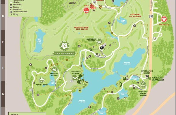
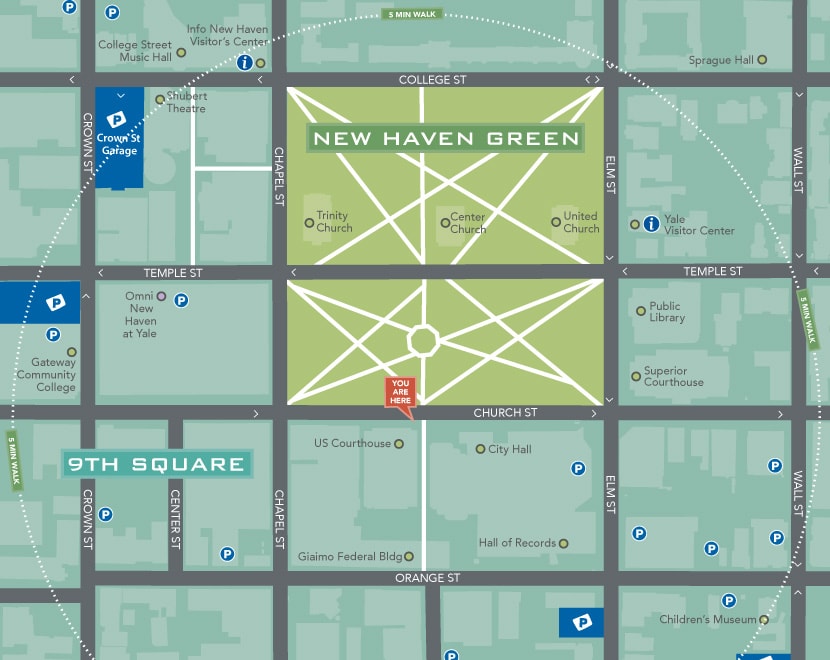
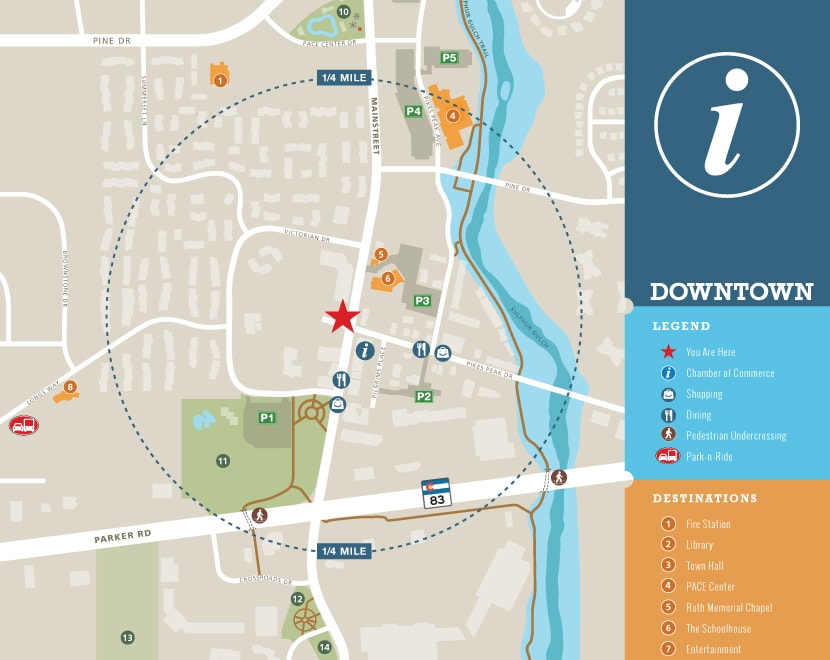
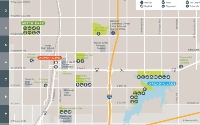
Cruise along the famed Route 66 you will arrive in Edmond,one of the best places to live in Oklahoma, Home to championship golf courses, indoor/outdoor food halls, downtown street festivals and local shopping and dining there’s a lot to do during your visit. You can explore Arcadia Lake, as well as 33 parks, 47 miles of trails, more than 300 public art pieces that provide the City a unique sense of community.

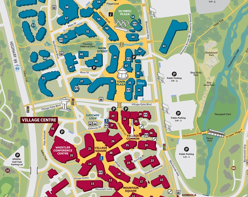
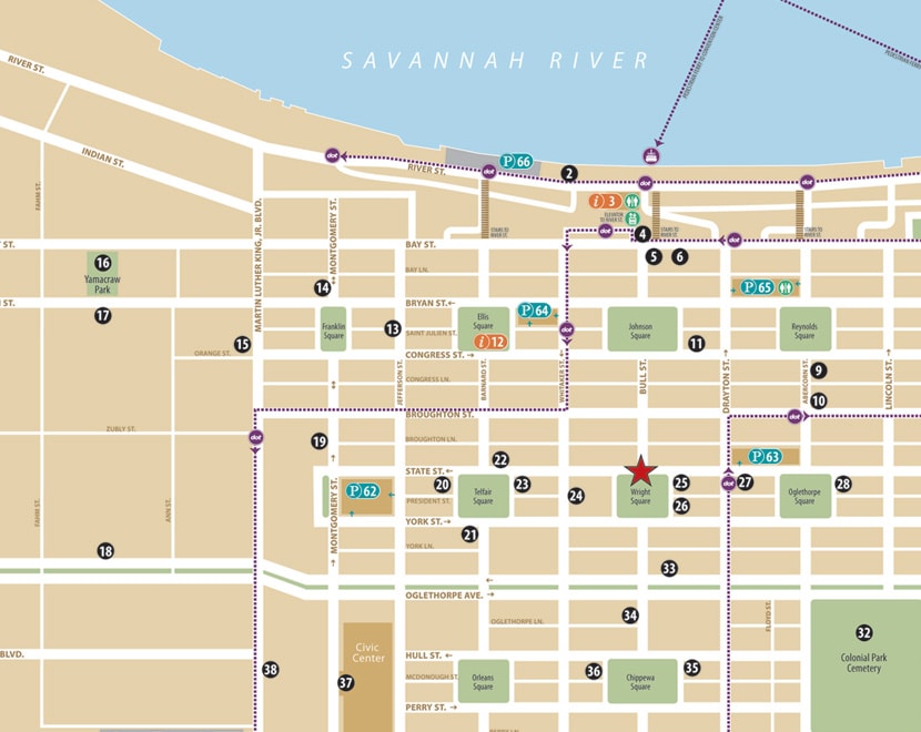
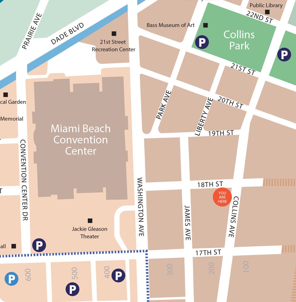
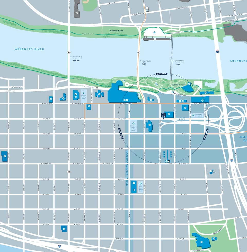
The wayfinding program designed by MERJE, guides motorists, bicyclists and pedestrians through streets of Edmond. The design takes cues from the local architecture and materials. The graphics incorporate pictograms to promote recreational activities, as well as a vibrant color palette accent for Downtown Edmond. Kiosk offer promotion of Community Events and include a new orientation map, also designed by MERJE.

Callaway Resort & Gardens

Callaway Resort & Gardens is a 2,500-acre resort complex located near Pine Mountain, Georgia. Attracting over 750,000 visitors annually, the property includes the world’s largest azalea garden and was ranked as Best Georgia Attraction in 2018 by USA Today. The property is owned and operated by Herschend Family Entertainment.

Over the years, on-site signage had become inaccurate, inconsistent and cluttered around the site. Based on our previous work with Herschend Family Entertainment, the company hired MERJE to conduct a Wayfinding Master Plan. The new plan clarifies entrances, creates zones and provides simplified messaging. Icons, color-coding and sustainable materials are utilized to create new entrance identification elements, street signs and vehicular directional signs.

The first initiative was the creation of a new orientation map, that establishes the graphic language for the overall wayfinding program. The use of color and zone icons are key component to the design.

IndyGo

IndyGo’s Red Line is a bold, new era of efficient, rider-focused Bus Rapid Transit for the City of Indianapolis. The first of its rapid transit lines it sets the standard for how the system will be planned, designed and built. For 13 miles, IndyGo’s new Redline is a milestone in improved capacity, comfort and comprehensive accommodation for every rider’s experience. The Redline runs 7 days a week, with frequency of 10-20 minutes. Its easy to ride and accessible to work, education, healthcare, restaurants, entertainment, and shopping.

Indygo contracted MERJE to develop the mapping series for the redline and overall IndyGo bus system. With 28 rapid transit stations, each stop received an individual map of the local area and connecting routes. A specific map was developed for the downtown that included additional detail about attractions, landmarks and amenities.

Boston Blue Bikes (LYFT)

Everything is better on a bike! Bluebikes is Metro Boston’s public bike share program, with over 3,000+ bikes and more than 300+ stations across Boston, Brookline, Cambridge, Everett, and Somerville. It’s a fun, affordable and convenient transportation option for quick trips around town.

Blue Bikes (owned by Lyft) hired MERJE to develop the mapping system that is posted at 300+ bike stations across the regional bike share program. The base maps were designed in coordination with each city and include bike locations, public transit (T) stations, parks, landmarks and local destinations. Each map is adjusted to its location, with ¼ and ½ mile radius information.

Whistler Orientation Map Close-Up

Whistler Maps

Signage alone cannot solve a wayfinding problem. Providing visitors with a variety of tools and presenting information in different forms helps to create a variety of touch points and opportunities to help people find their way.

Orientation maps, whether they are printed in a brochure, displayed on signage, or digital and interactive, are a common wayfinding tools. The use of consistent terminology and graphics across a range of mediums builds trust in the wayfinding program and gives the user confidence that the information being presented is accurate, up-to-date and part of an overall system.

Savannah Maps Close-Up

Savannah Maps

Signage alone cannot solve a wayfinding problem. Providing visitors with a variety of tools and presenting information in different forms helps to create a variety of touch points and opportunities to help people find their way.

Orientation maps, whether they are printed in a brochure, displayed on signage, or digital and interactive, are a common wayfinding tools. The use of consistent terminology and graphics across a range of mediums builds trust in the wayfinding program and gives the user confidence that the information being presented is accurate, up-to-date and part of an overall system.

New Haven Map Close-Up

New Haven Maps

Signage alone cannot solve a wayfinding problem. Providing visitors with a variety of tools and presenting information in different forms helps to create a variety of touch points and opportunities to help people find their way.

Orientation maps, whether they are printed in a brochure, displayed on signage, or digital and interactive, are a common wayfinding tools. The use of consistent terminology and graphics across a range of mediums builds trust in the wayfinding program and gives the user confidence that the information being presented is accurate, up-to-date and part of an overall system.

Parker Map Close-Up

Parker Maps

Signage alone cannot solve a wayfinding problem. Providing visitors with a variety of tools and presenting information in different forms helps to create a variety of touch points and opportunities to help people find their way.

Orientation maps, whether they are printed in a brochure, displayed on signage, or digital and interactive, are a common wayfinding tools. The use of consistent terminology and graphics across a range of mediums builds trust in the wayfinding program and gives the user confidence that the information being presented is accurate, up-to-date and part of an overall system.

Miami Map

Miami Beach Maps

Signage alone cannot solve a wayfinding problem. Providing visitors with a variety of tools and presenting information in different forms helps to create a variety of touch points and opportunities to help people find their way.

Orientation maps, whether they are printed in a brochure, displayed on signage, or digital and interactive, are a common wayfinding tools. The use of consistent terminology and graphics across a range of mediums builds trust in the wayfinding program and gives the user confidence that the information being presented is accurate, up-to-date and part of an overall system.

Little Rock Downtown Map Crop

Little Rock Maps

Signage alone cannot solve a wayfinding problem. Providing visitors with a variety of tools and presenting information in different forms helps to create a variety of touch points and opportunities to help people find their way.

Orientation maps, whether they are printed in a brochure, displayed on signage, or digital and interactive, are a common way finding tools. The use of consistent terminology and graphics across a range of mediums builds trust in the wayfinding program, and gives the user confidence that the information being presented is accurate, up-to-date and part of an overall system.