Henderson County wayfinding signs guide visitors to our attractions
HENDERSON COUNTY NC – Visitors and local motorists alike can more easily find attractions, public parking, government offices, parks and other destinations thanks to the countywide wayfinding project the Tourism Development Authority has now completed.
More than two years in the planning, design and execution, the $473,000 project resulted in 72 signs all around the county showing people how to reach popular destinations.
“It’s been like birthing a baby,” Beth Carden, the TDA’s executive director, said. “Sixty-eight doesn’t sound like a lot but when you start looking around they really pop and they’re very visible. We’re getting a lot of compliments already, people calling us and thanking us. I’ve seen a lot of them in different places and I’m probably biased but these are some of the prettiest I’ve seen.”
The number of signs is actually 72 on final count, said Lew Holloway, the city’s director of downtown and economic development. As a TDA member, Holloway coordinated the project from design through the planting of signs.
ColorAd, a Manassas, Virginia, company, did the design, manufacturing and installation for $433,912. Merje, of West Chester, Pennsylvania, developed a wayfinding master plan and reviewed bids from the sign manufacturers, for $39,485. (On its website, Merje says that it “‘merges’ graphic design with the built environment, helping cities, universities (and others) … enhance their brand and achieve their mission.” The company specializes in branding and identity, wayfinding and signage, architectural and visual enhancements, exhibit and interpretive design and print materials.
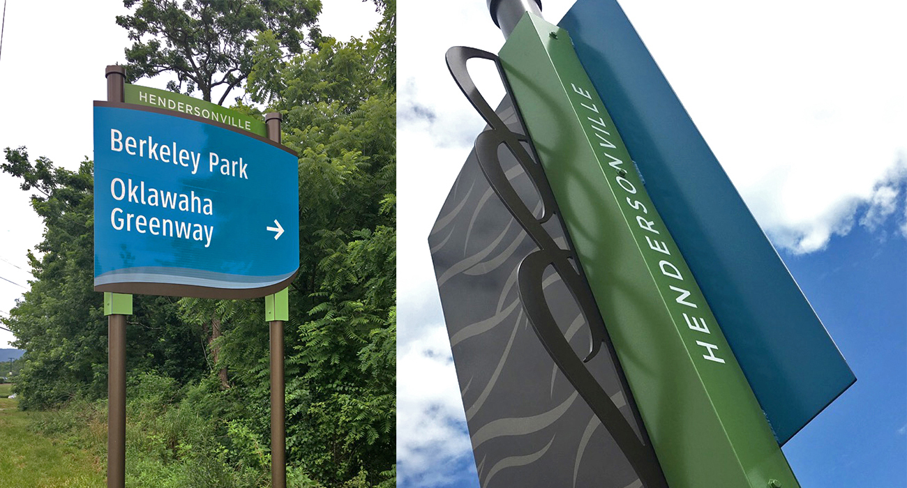
Closer to Carolina Panther blue than Carolina blue, the signs range in height from 10 to 13½ feet. Depending on size, they’re on one or two decorative lamp posts called American base and designed to withstand wind gusts of 90 mph. The white lettering, in a simple sans serif font called Gotham Medium, is 4 inches high where the speed limit is under 25 mph and 6 inches high where the speed limit is more than 25 mph.
The project involved a complicated and time-consuming exploration of what was worthy of signage and where each sign would go. Once the TDA and contractor planned each location, Holloway worked with the NCDOT for permission to plant them and worked with crews on “utility callouts.”
“We’re excited to see them up and out there,” he said.
Headers over the signs identify towns, each of which has a color theme. Hendersonville got green and medium blue, Fletcher, brown; Laurel Park, a darker blue; Mills River, orange; and Flat Rock, dark gray.
The signs aren’t just for visitors.
Local people might be unaware that Henderson County has numerous agricultural districts that seek to preserve and promote farming. The signs point to our “Agricultural Corridor” along U.S. 64 East in the apple country.
The signs direct travelers to town halls, colleges, parks and tourist destinations, including Westfeldt Park and Mills River Town Park (boat launch icons), the WNC Ag Center, Berkeley Park, the Oklawaha Greenway, Cane Creek Greenway, the Visitors Center, Bullington Gardens, Chimney Rock State Park, DuPont State Forest, Jackson Park, BRCC, the WNC Air Museum, Flat Rock Playhouse, Carl Sandburg Home, Jump Off Rock, the Boys and Girls Club, Historic Seventh Avenue, Patton Park, the Health Sciences Center, the Historic Courthouse and of course public parking. The TDA plans to celebrate completion of the project on June 12.
Bill Moss | Hendersonville Lightning